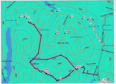


using aerial photography and mapping software in combination with my gps and stardust analyzer I came up with this revelation. if you go up through the Honolulu bowels and into the kachese ridge trail (#usfs4572) you continue along the very crest of the mountain for approximately four and a half miles of high elevation until dropping down to Thorpe lake and connecting with our hillclimbs at french creek!!!
way point number 81 is the area we jumped for the camera at the end of the day on the 12th. the purple line goes north along the ridge and into waypoint 79 , the playfield at the top of cooper. WE MUST TRY THIS ASAP!


0 Comments:
Post a Comment
<< Home